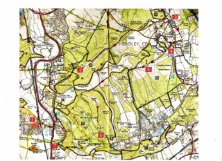
BOX HILL & WEST HUMBLE CIRCULAR VIA HEADLEY
Distance: 15 km (9 miles)
Maps: OS Explorer 146, Landranger 187
Walksurveyed and described by Sue Lea and Brian Keyte, based on Ken’s walk summary as follows:
A round walk in the attractive Surrey Hills on quiet paths and bridleways, starting and ending by the River Mole and with good views from high points at Mickleham Downs, Headley Heath, Juniper Top and Box Hill.
Description checked by Anna Harris, Margaret Spooner and Jackie Gower
START from Box Hill and West Humble train station, (1) (TQ167519) climb the steps from the station's small car park and cross the road. Take the footpath to the north by the railway fence and along the side of a large field which is part of the Norbury Park estate (its big white building stands on the hill ahead). Cross the River Mole on a footbridge beside the 4-arched railway bridge. (Notice some unusual way-marking there for Leatherhead to Dorking walkers). Continue ahead, then take the path to the right under the railway and up to the busy A24 road. Cross this carefully. A few metres to the left the signposted path continues up through trees and crosses a driveway. Follow the path through two fields near the boundaries and go uphill into trees again. When you reach a B-road, turn right along the pavement for about 100 metres then stay on the path just below the road to the T-junction with Headley Lane. Cross over to walk up Headley Lane, almost immediately turning up to the left to take the obvious bridleway, Downs Road, and continue steadily uphill.
After about 1 km where a track crosses, continue ahead towards Mickleham Downs. Just after a path, which joins diagonally from the left, take the track up to the right beside a gate. Coming out of the trees onto the Downs, you pass near an old trig point to your left (2) (TQ179535) and reach the start of 'The Long Ride', a straight and open grassy clearance. Follow this wide path north-east on gently rising paths until the trees close in on both sides near an information board about “Archeology on Mickleham Downs”. Continue straight ahead on a bridleway in the woodland until you reach a car park. Here the bridleway turns to the right beside a B-road and soon crosses the road to continue as a byway, Langley Lane, with the Nower Wood nature reserve on your left. (A little further on there is an alternative footpath to the right which crosses fields with good views, re-joining Langley Lane just before it ends at Slough Lane). At the quiet Slough Lane, turn left and walk up to the busier Church Lane at Headley. There you turn right along the road or on the footpath beside it and soon reach Headley Church on the left. (3) (TQ205548) The Cock Inn is just beside the driveway to the church (food available).
At the Church, take the path through the lych-gate and across the churchyard to the right of the church, leaving the churchyard through a second lych-gate. Turn immediately right and follow a path straight ahead through a series of kissing gates and across the driveway by The Old Rectory. Go through a kissing gate and uphill. A little before a large house ahead, turn right onto a crossing path. This soon joins a driveway from Webbs Farm and converges with Church Lane. Take the minor road immediately opposite, Nut Ash Lane, and at the first house turn left onto a track which almost immediately crosses a B-road.
The track continues as a private road / bridleway, passes a large house on the right and leads to Headley Heath. When the track turns to the right (4) (TQ204540) continue on the bridleway straight ahead through a conspicuous gate. Continue ahead southwest across the Heath on the fairly level track, ignoring several tracks and paths joining it. In less than 1 km you reach a point where five tracks come together. After 100 metres on the wide path ahead you reach a viewpoint (5) (TQ198535) where there are several seats and more paths meet.
Take the stony track to the right which leads downhill and starts to fall quite steeply with good views to the left. At the bottom, continue ahead where paths come down with many steps to join it on both sides. When the track arcs to the left, take the bridleway which leaves it on the right. This stony path turns steeply up a water-worn gully in the chalk. You soon reach the private road by the buildings at High Ashurst outdoor centre. Turn sharply right past the outdoor centre and walk down the road for 1 km. When it starts to turn very sharply right at a junction, continue in the same direction up the track ahead. Go straight on where a track joins from the left and look out for the distant spire of the 'Church on the North Downs Way' on the horizon straight ahead of you. When the track turns right to Warren Farm, again continue straight ahead on a footpath which follows the edge of a wood before turning up and winding through it.
A stile marks the edge of the wood and the level path continues for a little way before reaching the open lower slopes of Juniper Top. Turn sharp left to climb the broad green ridge, passing seats higher up with good views to the north-west. At the top, go a little to the right and through gates on a level track going south in the extensive woodland. After 1 km, at a marker post (6) (TQ184516) take the right fork onto a level track. At the next junction where tracks cross continue ahead, ignoring other tracks going off to the side, until the path emerges from the wood into open green spaces, past a donation pillar and a car parking area. Keep slightly right and you will soon see the National Trust cafe and visitor centre.
Take the surfaced path from the teashop, soon diverging from the road, to the Box Hill viewpoint. Having enjoyed the extensive view to the south, go down the steps and turn right onto the level path, the North Downs Way, with the view on your left. At the second gate, take the signed path which goes gently downhill at first, then steeply with many steps (careful!) until you arrive at the River Mole and the Stepping Stones. (7) (TQ172513) Many walkers may prefer to cross the river by the footbridge a short way downstream but survivors of the Stones also have paths to the right leading to the bridge.
Here you leave the North Downs Way, taking the wide path which crosses the fields staying close to the river. The A24 is reached at a bridge and the path climbs to join it. Cross the road by the subway and go up to the left to join the minor road which goes past the Stepping Stones PH to your starting point at the train station.